Categories
Shopping cart (0 items € 0)
Advanced search

Middle East & Islamic World / Arabian Peninsula & Gulf States

The Ottoman-Mamluk war and the conquest of Mecca and Medina

[OTTOMAN-MAMLUK WAR]. 
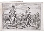
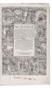
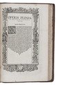
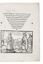
Omnia que gesta sunt in Orie[n]te inter Sophi & Maximum Turcarum & Suldanum, & que[m]admodum dux Turcaru[m] caepit Alepum & Damascum & Hierusalem cum om[n]ibus circumiace[n]tibus oppidis, & quo[rum] maximus Turcaru[m] voluit audire una[m] missam apud sanctu[m] sepulchru[m] Iesu Christi.
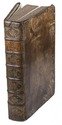
[Basel, Pamphilus Gengenbach, 1518]. 4to. With woodcut illustration on title-page. 19th-century pink wrappers. [6], [2 blank] pp. Full description
€ 35,000
Order Inquire Terms of sale

Warmly inscribed by the author

PALGRAVE, William Gifford. Personal narrative of a year's journey through Central and Eastern Arabia (1862-63).
London and New York, Macmillan and Co., 1871. 8vo (ca. 13 x 19 cm). With a linen-backed folding map and 3 extending plans. Contemporary half morocco with maroon cloth over boards, gilt, front board stamped with the owner's initials "G.W.T.", marbled endpapers. [2], VI, [4], 421, [1] pp. Full description
€ 2,500
Order Inquire Terms of sale

Map of Alios Musil's journeys

PEUCKER, Karl. Musils explorations in Northern Arabia, 1908-9.
[London, W. Clowes, May 1910]. With a full-page black and white lithographed map (19x12.5 cm). 4to. With a full-page lithographed black and white map. Modern blue wrappers. 579-581 pp. Full description
€ 300
Order Inquire Terms of sale

The first European crossing the Rub' al-Khali (Empty Quarter) of Arabia from east to the west

PHILBY, Harry St. John Bridger and Alfred Felix Landon BEESTON. Sheba's daughters beign a record of travel in southern Arabia. With an appendix on the rock inscriptions by A.F.L. Beeston.
London, Methuen & Co., [1939]. 4to. With photographic frontispiece, 46 photographic plates (1 of which double-page), 1 folding map of southern Arabia, and several photographic illustrations in the text. Contemporary light yellow cloth with giltstamped title and ornament to the spine. XIX, [1 blank], 485, [1] pp. Full description
€ 350
Order Inquire Terms of sale

One of the earliest sources on the Congo and central Africa, complete with all plates and maps

PIGAFETTA, Filippo and Duarte LOPEZ. Relatione del reame di Congo et delle circonvicine contrade tratta dalli scritti & ragionamenti di Odoardo Lopez.
Rome, Bartolomeo Grassi, [1591]. 4to. With an integral engraved architectural title-page (with the coat of arms of the dedicatee Antonio Migliore, Bishop of San Marco), large folding engraved general map of Africa (64×44 cm), large folding engraved map of the Congo (43.5×51.5 cm) and 8 numbered folding engraved plates of plants, animals and inhabitants of the country, by Natalis Bonifazio. Contemporary limp sheepskin parchment. [8], 82, [1], [1 blank] pp. Full description
€ 60,000
Order Inquire Terms of sale
170 books found / Show all