Categories
Shopping cart (0 items € 0)
Advanced search

Cartography & Exploration / Atlases, Charts, Maps & Globes

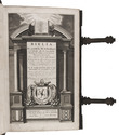
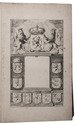
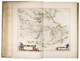
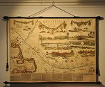
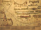
Very rare map of North Holland in 1575

BEELDSNIJDER, Joost Jansz. 
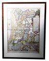
Vernieuwde Kaart van Noordholland en Westfriesland, benevens het voornaamste gedeelte van Rhynland, en daar aan grenzende Landen.
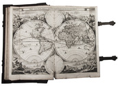
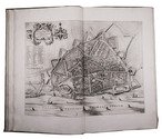
Amsterdam, Yntema & Tieboel, 1778. (92 x 68 cm). Large hand-coloured engraved map on 2 sheets, decorated with arms, figures and products from the regions shown, and with the title at the foot. Framed. Full description
€ 7,250
Order Inquire Terms of sale

Wonderful and very rare nautical atlas for the Mediterranean

BERTHELOT, François. [Nautical atlas of the Mediterranean Sea].
Marseille, "se vend chez Benoît", 1720-1730. Large folio (40 x 55 cm). With 4 double-page engraved maps, with the first half of the first map as the front paste-down and the second half of the last map as the back paste-down. Contemporary vellum-backed boards, reinforced with light brown leather at the head and foot of the spine. 4 nautical maps on [8] pp. Full description
€ 8,500
Order Inquire Terms of sale

Keur Bible with 6 maps and 51 plates

[BIBLE - DUTCH]. Biblia, dat is de gantsche H. Schrifture, vervattende alle de Canonijcke Boecken des Ouden en des Nieuwen Testaments.
Dordrecht, Hendrick, Jacob and Pieter Keur; Amsterdam, Marcus Doornick and Pieter Rotterdam, 1702. Large folio (42.5 x 27 cm). With engraved title-page, 2 letterpress title-pages with woodcut printer's device, 1 half-title, double-page engraved world-map, 5 double-page engraved maps and 1 plan, 51 engraved plates with 6 illustrations each, the latter by Lamberecht Causé and Nicolaas Gommerse. Contemporary blind-tooled calf over wooden boards, with brass cornerpieces, clasps and catches. [20], 302; [2], 134; [12], 164; [2], 66 ll. Full description
€ 4,500
Order Inquire Terms of sale

Large paper copy of the first Dutch edition of Blaeu's great atlas of cities and towns of the Dutch Republic, with 320 mostly double-page maps, plans and views

BLAEU, Joan. [Toonneel der steden van de Vereenighde Nederlanden, met hare beschrijvingen, ...].
With: [Toonneel der steden van s Konings Nederlanden, met hare beschrijvingen, ...].
[Amsterdam, Joan Blaeu, 1652]. 2 volumes. Atlas folio (57 × 37 cm). With two engraved architectural title-pages, each with a blank central panel where a letterpress slip with the title and the publishers name would have been pasted; 181 (Dutch Republic) & 139 (Spanish Netherlands) maps, plans and views plus 2 smaller engravings in text; 20 woodcut illustration figures in the text. Uniform, early 18th-century(?) half red sheepskin. Full description
€ 68,500
Order Inquire Terms of sale

First edition of Blaeu's atlas of Scotland and Ireland, beautifully coloured and highlighted with gold

BLAEU, Joan. Vyfde stuck der aerdrycksbeschryving, welck vervat Schotlandt en Yrlandt.
Amsterdam, Joan Blaeu, 1654. Atlas folio (57.5 x 39.5 cm). With engraved architectural title-page with the arms of Scotland filling the top half, elaborately crested, supported by unicorns with flags and still with the old Stuart royalist mottos, and 55 engraved maps (54 double-page and 1 of the Irish County Caterlogh, full-page), often richly adorned with additional cartouches with regional scenes, but most often with coats of arms from the region. Numerous woodcut tailpieces and decorated initial letters. The title-page and all maps, including the cartouches, scenes and coats of arms, beautifully coloured by hand and highlighted with gold. All maps in their first states, without added ships or compass roses. 17th-century Dutch gold-tooled vellum. [8], 189, [1 blank], 70, [1, 1 blank] pp. Full description
€ 24,000
Order Inquire Terms of sale

Fine untrimmed copy of a pilot guide, with coloured maps and aquatint profiles

BOUGARD, René and John Thomas SERRES. The little sea torch: or, true guide for coasting pilots.
London, J. Debrett for the "author" [Serres], G. & W. Nicol, et al. [printed by T. Rickaby], 1801. Large folio (47 x 30 cm). With 20 numbered aquatint plates containing 137 coastal profiles, and 12 partly numbered engraved plates containing 24 maps of port cities, harbours, islands and the Strait of Gibraltar. All coastal profiles and maps beautifully and subtly coloured by a contemporary hand. Contemporary boards. VI, 144, [5] pp. Full description
€ 14,500
Order Inquire Terms of sale

Excellent early 20th-century facsimile of Marcgraf's famous large wall map of Dutch Brazil, in colour

[BRAZIL - WALL-MAP]. MARCGRAF, Georg and Frans POST. Brasilia qua parte paret Belgis. Nederlands Brasilien.
The Hague, Martinus Nijhoff, 1923 (after the original published in Amsterdam by Joan Blaeu in 1647). ca. 120 x 160 cm. Large wall map of Dutch Brazil, comprised of ca. 11 paper leaves pasted on linen to form the entire rectangular map, mounted between two black wooden rods at the head and foot of the map. The map shows an exact representation of the Brazilian coast from Rio Grande do Norte and the Sergipe region, all illustrative details and the cartouches are beautifully professionally coloured and the map is accompanied by a descriptive text about Dutch Brazil along the foot of the map, including a decorated initial. Full description
€ 9,750
Order Inquire Terms of sale

Early 19th century edition of a woodcut plan imaging Nagasaki and Deshima

[MAP] BUNKINDO HAN. Hishu Nagasaki (no) zu (plan of Nagasaki, Hizen province).
(Nagasaki, Bunkindo, 1821). 615 x 870 mm. Large folding woodcut map of the port and city of Nagasaki, printed in three colours (ochre, blue and green) on four sheets. In Japanese ochre paper etui decorated with blue and white flowers and title label with Japanese characters pasted on, preserved in later dark blue cloth slipcase in Japanese style closing with two ivory clasps. Full description
€ 2,950
Order Inquire Terms of sale

Beautifully illustrated expeditions searching for ancient Egyptian antiquities

CAILLIAUD, Frédéric and Bernardino DROVETTI. Voyage a l'Oasis de Thèbes et dans les déserts situés a l'orient et a l'occident de la Thébaïde, fait pendant les années 1815, 1816, 1817 et 1818.
Paris, Royal press, 1821. With 24 numbered engraved plates, including 2 engraved maps (1 folding), 1 plate coloured by hand and 1 double-page.
With: (2) CAILLIAUD, Frédéric and Bernardino DROVETTI. Voyage a l'Oasis de Syouah ... pendant leurs voyages dans cette oasis, en 1819 et en 1820.
Paris, Rignoux, 1823. With 20 numbered plates (1 engraved map and 19 lithographed plates). 2 works in 1 volume. Folio. Contemporary green goatskin morocco, richly gold-tooled spine. [2 blank], XVII, [1], 120; [12], 28 pp. Full description
€ 19,500
Order Inquire Terms of sale
135 books found / Show all
Recently viewed