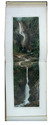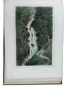

Beautiful water colour of a rural scene near Arnhem
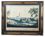
[ARNHEM]. HILVERDINK, Jacobus Wilhelmus Adrianus.
'Een boeren landschap. Omstreken van Arnhem'.
1834. 56 x 38.5 cm. Glazed in a contemporary ornamented gold painted wooden frame (57 x 71 cm). Full description
€ 4,500
1834. 56 x 38.5 cm. Glazed in a contemporary ornamented gold painted wooden frame (57 x 71 cm). Full description