Categories
Shopping cart (0 items € 0)
Advanced search

Cartography & Exploration / Middle East & Islamic World

Extremely rare example of the largest globe engraved by Malby (45.5 cm diameter), with lines of magnetic variation, London 1848, showing “Debai” (Dubai)

[GLOBE - TERRESTRIAL]. MALBY & CO. Malby's terrestrial globe.
[London], Malby & Co. (engraved by Chas. Malby), 1 January 1848. Diameter: 45.5 cm (18 inch), height in stand: 64.5 cm. An engraved terrestrial globe with 12 gores and 2 polar caps over a plaster-covered core, and the engraved horizon ring on the wooden stand, all coloured by a contemporary hand. In a contemporary wooden stand with 3 turned legs supporting the horizon ring, and 3 turned stretchers with a cylindrical centrepiece with a knob on the underside. Further with a contemporary brass hour circle and a slightly later iron meridian ring (and probably the axis pivots). Full description
€ 35,000
Order Inquire Terms of sale

One of the fullest descriptions of life in Sana'a and Turkish-occupied North Yemen

MANZONI, Renzo. El Yèmen. Tre anni nell'Arabia felice. Escursioni fatte dal Settembre 1877 al Marzo 1880.
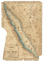
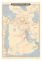
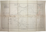
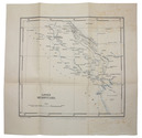
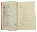
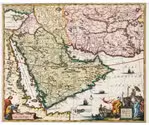
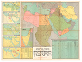
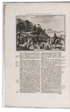
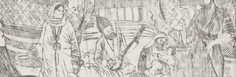
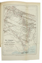
Rome, Botta heirs, 1884. 8vo. With a frontispiece portrait, 21 plates (including 7 double-page sized; the last single-page plate included in pagination), 2 folding colour-printed maps of Yemen, folding plate of the game "abdùr", folding coloured plan of Sana'a, folding view of Sana'a, folding view of Aden, as well as numerous woodcut illustrations in the text. Contemporary half calf over marbled boards with blind-stamped spine and gold-stamped spine-title. Marbled endpapers. [8], VI, [2], 446 pp. Full description
€ 2,500
Order Inquire Terms of sale

Cross-cultural mapping of the Red Sea: Bruce's chart in an early Egyptian manuscript copy

[MAP - ARABIAN PENINSULA]. BRUCE, James. Carte de la mer Rouge, relevée sur celle de James Bruce.
[Egypt, probably Cairo], 1827. Folio leaf (46 x 31.5 cm). Manuscript map in pen and ink with watercolour, with a French text on Middle Eastern hand-made paper. Full description
€ 15,000
Order Inquire Terms of sale

Abu Dhabi's Oil industry: the Israeli perspective

[MAP - ARABIAN PENINSULA OIL RESOURCES]. Neft ba-mizrah ha-tikhon. Zikaynot, shadot, tzinorot, batei zikuk. [= Oil in the Middle East. Concessions, oilfields, pipelines, refineries].
Tel Aviv, Israel Defence Forces, General Staff, [1957]. 56 x 82.5 cm. Chromolithographic map of the Arabian Peninsula, from Turkey in the north to the Indian Ocean in the south, and covering Saudi Arabia, Egypt, Israel, Palestine, Jordan, Syria, Lebanon, Iraq, Iran, Kuwait, Bahrain, Qatar, United Arab Emirates, Oman, North and South Yemen. Scale 1:5,000,000. Scale and key in Hebrew inset to top-right, inset explanatory panels in Hebrew and English, compass rose in Saudi Arabia. Folded. Full description
€ 7,500
Order Inquire Terms of sale

"For offical use only": mapping the Mesopotamian battlefields of WWI

[MESOPOTAMIAN CAMPAIGN]. Critical study of the campaign in Mesopotamia up to April 1917. Part II - Maps.
Calcutta, Government of India Press, 1925. 25 (of 26) folding maps, sketches etc., as always lacking the "Explanation of the Method of giving Map Co-ordinates adopted in Chapters XIII and XX". Original tan cloth map-case with original printed label to cover. 25 (of 26) folding ll. Full description
€ 3,500
Order Inquire Terms of sale

The climate of the East African coast

[ARABIAN GULF]. Weather in the Indian Ocean to Latitude 30° S. and Longitude 95° E. Including the Red Sea and Persian Gulf. Volume II. Local information. Part 9 Coast of East Africa from the equator to Cape Delgado [...].
London, Meteorological Office, Air Ministry, 1940. 8vo. With map frontispiece and several illustrations and tables in the text. Original publisher's printed red wrappers. 63 pp., final blank page. Full description
€ 1,500
Order Inquire Terms of sale

Instructions for Carsten Niebuhr's expedition to Arabia

MICHAELIS, Johann David. Recueil de questions, proposées à une société de savants, qui par ordre de Sa Majesté Danoise font le voyage de l'Arabie.
Amsterdam, S.J. Baalde; Utrecht, J. van Schoonhoven & comp., 1774. 4to. Set in roman type with incidental Greek, Hebrew, Arabic, Syriac and 1 word in Coptic. Near-contemporary tanned sheepskin, gold-tooled spine. [4], XLIV, 256, [16], 38, [2 blank] pp. Full description
€ 3,500
Order Inquire Terms of sale

Enormous panoramic Middle Eastern view with ruins, nearly 6 metres long

[VIEW - MIDDLE EAST]. [Mountainous landscape with Middle Eastern and classical Roman ruins, 6 shepherds with their flocks, several figures riding dromedaries and one riding a donkey, (date?) palms, lakes, etc.].
[Palestine?, ca. 1910?]. An enormous panoramic view drawn in coloured gouaches on a single, continuous roll of paper (70 x 583 cm), the drawing running to the edges of the paper. Full description
€ 35,000
Order Inquire Terms of sale
127 books found / Show all