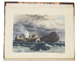
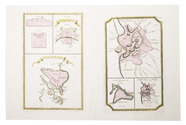
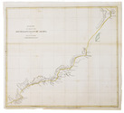
Categories
Shopping cart (0 items € 0)
Advanced search

Cartography & Exploration

Including the first illustration of Niagara Falls and first engraving of an American bison

HENNEPIN, Louis. Nouvelle decouverte d'un tres grand pays situé dans l'Amerique, entre le Nouveau Mexique, et la mer glaciale.
Amsterdam, Abraham van Someren, 1698. 12mo. With engraved frontispiece by Caspar Luyken, 2 folding engraved maps and 2 folding engraved plates. Contemporary mottled calf, gold-tooled spine. [72], 1-312, [10], 313-506 pp. Full description
€ 8,000
Order Inquire Terms of sale

Large chart of European countries and their royal or noble families

[HERALDIC CHART - EUROPE]. SPECHT, Caspar. Historische en geographische tafel om te leren een kort begrip vande landen en staaten in Europa haar grootheyd, besitting en alles dat tot onderricht der liefhebbers van de landbeschryvinge dienen kan.
Amsterdam, Reinier and Joshua Ottens, [before 1750]. Engraved chart (47.5 x 57 cm) printed on a single sheet of paper (51.5 x 64 cm), coloured by hand, including several coats of arms. Full description
€ 250
Order Inquire Terms of sale

The Desert of Paran and the 42 stations of the Exodus, with a map

HERMANN, Amand. Desertum Pharan mystice explicatum, cum quadraginta duabus in eo mansionibus filiorum Isràél ad Palaestinam pergentium: . . .
Kalisz, printed by the college of the Society of Jesus, 1685. 4to. With an engraved frontispiece, showing a map of the Holy Land and the route of the Exodus with the 42 stations numbered. Contemporary overlapping vellum. [32], 505, [1 blank], [16] pp. Full description
€ 1,950
Order Inquire Terms of sale

Unveiling Australia and the New World

HERRERA Y TORDESILLAS, Antonio de. Descriptio Indiae Occidentalis. Nieuwe werelt, anders ghenaempt West-Indien.
Amsterdam, Michiel Colijn, 1622.
With:
(2) ORDONNEZ DE CEVALLES, Pedro. Eyghentlijcke beschryvinghe van West-Indien, hoe die landen en provintien gheleghen zijn op wat maniere dat men die door reysen sal: ende wat rijckdommen van gout en silver elcke plaetse begrijpt.
Amsterdam, Michiel Colijn, 1621.
(3) [LE MAIRE, Jacques]. Spieghel der Australische navigatie door den wijt vermaerden ende cloeckmoedighen zee-heldt Jacob Le Maire, president ende overste over de twee schepen, d' Eendracht ende Hoorn, uytghevaren den 14 Junii 1615.
Amsterdam, Michiel Colijn, 1622.
3 works in 1 volume. Small folio. With an engraved title, 17 engraved folding maps, an engraved portrait, 5 engraved plates in text, and woodcut head- and tailpieces. Contemporary vellum, with the manuscript title on the spine. [6], 111; 29; [16], 98 pp. Full description
€ 25,000
Order Inquire Terms of sale

Popular story of an East Indiaman wrecked off the coast of Bengal

HEYDEN (HEIDEN), Frans Jansz. van der. Vervarelyke schip-breuk van 't Oost-Indisch jacht Ter Schelling, onder het landt van Bengale; ... beneffens een bondige beschryving der Koningryken van Arrakan, Bengale, Martavan, Tanassery, ... Den vyfden druk doorgaens met platen verciert.
Harderwijk, Jan Rampen, 1722. 4to. With 18 woodcut illustrations plus 1 repeat. Modern half vellum. 96 pp. Full description
€ 2,250
Order Inquire Terms of sale

Fine work illustrating the cities, ports, and factories of the Dutch East India Company in Asia and Africa

HEYDT, Johann Wolffgang. Allerneuester Geographisch und Topographischer Schau-Platz, von Africa und Ost-Indien.
Nuremberg, C. Tetschner, 1744. Oblong folio (31 x 36.5 cm). With 115 numbered engraved maps and plates, an engraved frontispiece, and an engraved title page. Contemporary vellum, with the author and title lettered in gold on the spine, red edges. [24], 345, [4] pp. Full description
€ 17,500
Order Inquire Terms of sale

The first British trade agreement with Mocha

[HEYNES, Edward]. Scheeps-togt van Mr. Edward Heynes, van Suratte na Mocha, gedaan in het jaar 1618. Verhalende, op wat wijse de Engelsse de koopmanschap, met de inwoonders, aldaar hebben opgerigt, en door schriftelijk verseekeringen (van den Bassa gegeeven) vast-gestelt. Als mede een beschrijving van de stad Mocha, des selfs huysingen, bolwerken en haven-plaats.
Leiden, Pieter van der Aa, [ca. 1707?]. Folio (25.5 × 40 cm). Modern blue-grey paper covers. [5] ll. (text in 2 columns per page, 4 per leaf, 14 cols. in total). Full description
€ 850
Order Inquire Terms of sale

A magnificent copy of a classic world atlas, hand-coloured and sumptuously bound

HOMANN, Johann Baptist. Grosser Atlas über die gantze Welt.
Nuremberg, Homann heirs (printed by Johann Heinrich Gottfried Bieling), 1737[-1762]. Folio (34 x 53.5 cm). Letterpress title-page printed in red and black with an engraved map of the northern hemisphere in a polar projection, engraved frontispiece with a globe and a dozen allegorical figures (with a decorated cartouche at the foot giving the title in Latin), engraved portrait of Homann by Johann Wilhelm Winter after Johannes Kenckel, and 98 engraved maps (93 double-page, 1 larger folding in 2 sheets and 4 half-page together on a double-page plate) many with further inset maps and/or views, all with decorated cartouches, often with pictorial decoration or coats of arms; and 3 double-page engraved tables of topographic data. With the engraved title-page and all maps and tables (except for the small north polar projection on the letterpress title-page) coloured by an 18th-century hand, the maps in part or in outline. Gold-tooled red morocco (ca. 1800?) in a neo-classical style, from the workshop of or in the style of Georg Friedrich Krauss (Vienna). [3], [1 blank], 40 pp. plus frontispiece, portrait and 99 double-page plates. Full description
€ 85,000
Order Inquire Terms of sale
664 books found / Show all