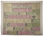

Official map of the Hejaz railway, from Damascus to Medina
(with the planned extension to Mecca, never built)
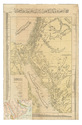
[HEJAZ RAILWAY].
[Map and profile of the Hijaz Railway route].
Constantinople, Matba a-i Bahriye, 1320 Rumi [= 1904 CE]. Colour-lithographed map (76.5 x 49.5 cm), trimmed to neat line. Full description
€ 22,000
Constantinople, Matba a-i Bahriye, 1320 Rumi [= 1904 CE]. Colour-lithographed map (76.5 x 49.5 cm), trimmed to neat line. Full description