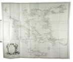
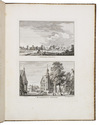
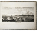
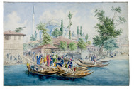
Categories
Shopping cart (0 items € 0)
Advanced search

Cartography & Exploration

Incredibly rare collection of views by De Beijer and Van Liender of the castles, houses,
churches and towns surrounding the city of Kleve in a spectacular 18th-century Dutch binding

[KLEEFSCHE OUTHEEDEN - VIEWS]. BEIJER, Jan de (draughtsman) and Paulus van LIENDER (engraver). Verzameling van twaalf Kleefsche outheden en gezichten.
Amsterdam, Gerrit Tielenburg, (signed in the plates:) 1758-1762. Large 4to (29 x 23 cm). With 50 leaves showing 46 engravings containing a total of 91 views: 42 leaves with 2 views per leaf, 6 leaves with 2 double page views each, and 1 double page view on 2 leaves. All engraved plates are signed "J. de Beyer del. Paul: van Liender fec [year: between 1758 and 1762]". All views are captioned beneath the illustration, telling the viewer what building, town, or view they are seeing, and some captions even mention the year when the view was captured by De Beyer. Near contemporary (ca. 1778) elaborately gold-tooled red morocco, with a green morocco title-label lettered in gold on the spine, gold-tooled edges and turn-ins, floral decorated paper end leaves, gilt edges. [1], [1 blank] pp. and 50 leaves showing 91 engraved views. Full description
€ 12,500
Order Inquire Terms of sale

1824 description and atlas of the United States of America, with views of New York and Philadelphia

KLINKOWSTRÖM, Axel. Bref om de Förenta Staterna, författade under en resa till Amerika, ären 1818, 1819, 1820. ... Förra[-Senare] delen.
Stockholm, Ecksteinska Tryckeriet, 1824. 3 volumes, the 2 text volumes bound as 1. 8vo (text) & 1mo (atlas, 42 x 56 cm). Each text volume with the same engraved title-page, and in volume 1 a folding letterpress table. The atlas volume has a lithographed title-page with a view of the White House, 2 large engraved maps of the northern part and the southern part of the United States by John Melish, dated 1816, and 14 maps, plans and views of New York, Philadelphia and Washington, including 8 fine engraved aquatints by Akrell. Bound in the atlas volume are 2 letterpress 4to leaves, one with the numbered list of 19 plates: the 2 engraved title-pages for the text volumes (1-2), lithographed title-page for the atlas (3) and 16 plates for the atlas (4-19: seven are 1mo - full or nearly full sheets - and nine smaller).
With: (2) [KLINKOWSTRÖM, Axel]. Atlas til Friherre Klinckowströms Bref om de Förente Staterne.
[Stockholm, Ecksteinska Tryckeriet, 1824]. Contemporary half sprinkled calf with the volume numbers 1 & 2 in half tanned sheepskin. IX, 242, [2]; VIII, [2], 243-496 pp. Full description
€ 7,000
Order Inquire Terms of sale

Rare publication by the Royal Dutch Meteorological Institute containing 24 charts of the currents
in the Gulf of Guinea and around the equator

KONINKLIJK NEDERLANDSCH METEOROLOGISCH INSTITUUT. [KLUIT, M.E.B.J. and P.F. van HEERDT]. De Guinea en Equatoriaal stroomen voor iedere maand afzonderlijk bewerkt volgens de gegevens van 2900 journalen, gehouden aan boord van Nederlandsche schepen.
Utrecht, printed by stoom-, boek- en steendrukkerij "De Industrie", J. van Druten for the KNMI, 1895. Folio (58 x 36,5 cm). With 24 double-page charts of the currents in the Gulf of Guinea off the West-African coast, 2 charts for each month, printed in blue, black and red. Half buckram and marbled paper over boards. [1], [1 blank], [1], [1 blank], [3], [1 blank] pp. and 24 double page charts. Full description
€ 1,950
Order Inquire Terms of sale

Rare heraldic game for young noblemen, improving and displaying their knowledge
of the genealogy, heraldry, geography and history of the main regions of Europe

KNOOP, Johann Hermann. Vermakelyk wapen-kundig, geographisch, en historisch spel, betreffende de voornaamste heerschende staten in Europa. En dienende om de jonge lieden, inzonderheid die van een meer als gemeene geboorte of educatie zyn, de wapen-kunde, geographie en historie gelyk als speelender wyze te leeren.
Amsterdam, David Klippink, 1768. 8vo. With a full-page engraved armorial plate with the coat-of-arms of the British chivalric Order of the Garter with their motto "Honi soit qui mal y pense" and small woodcut hearts, clubs, spades and diamonds in a card game in the text. 19th-century brown cloth, yellow endpapers. [24], 203, [5] pp. Full description
€ 1,250
Order Inquire Terms of sale

The most richly illustrated edition of a famous description of South Africa

KOLB (KOLBE), Peter. Naaukeurige en uitvoerige beschryving van de Kaap de Goede Hoop.
Amsterdam, Balthazar Lakeman, 1727. 2 volumes bound as 1. Folio. With engraved title-page, engraved portrait of the author, 6 engraved maps (including one large folding map, 42.5 x 54.5 cm), 1 engraved plan and 45 engraved plates. 18th-century tanned sheepskin with a tree pattern, gold-tooled spine. [20], 529; [6], 449, [87] pp. Full description
€ 7,500
Order Inquire Terms of sale

Captain's journal of the voyage of the steam ship "Cornelis Dirks" to Africa and South America

KOOPMAN, J.F. Verslag van eene reize naar de westkust van Afrika, Rio de Janeiro en Rio de la Plata, door Z.M. schroef-stoomschip Cornelis Dirks, ...1859-1860.
[Amsterdam, widow of G. Hulst van Keulen, 1863]. 8vo. Contemporary blue paper wrappers. [2 blank], [2], 127, [1 blank] pp. Full description
€ 1,500
Order Inquire Terms of sale

Large map depicting the world's oil industry, including the Middle East and Egypt

KORYTKO, Stefan. General orientative map of the world's oil industry | Übersichtskarte der Welt- Naphtha-Industrie | Carte d'orientation de l'industrie de pétrole du monde | Mapa pogladowa swiatowego przemyslu naftowego.
Lviv, Stefan Korytko, 1925. Large folding chromolithographed map (map size 65.5 x 88 cm). Original publisher's printed paper wrappers. Full description
€ 6,500
Order Inquire Terms of sale

24 lithographed Dutch city and harbour views

KOSTER, Everhardus. Schetsboek. Nederlandsche stads- en havengezigten.
Amsterdam, F. Buffa & son; Delft, H. Koster; Leiden, P.H. van den Heuvel, 1858. Folio. With letterpress title-page, lithographed portrait of Koster and 24 tinted lithographed views of Dutch cities and harbours by Johannes Hilverdink after Everhardus Koster, printed by Steuerwald. Contemporary half calf. [26] ll. Full description
€ 1,500
Order Inquire Terms of sale

The original and best edition of an important circumnavigation and Russian expedition
to the Bering Strait during the years 1815-1818

KOTZEBUE, Otto von. Entdeckungs-Reise in die Süd-See und nach der Berings-Strasse zur Erforschung einer nordöstlichen Durchfahrt. Unternommen in den Jahren 1815, 1816, 1817 und 1818, auf Kosten Sr. Erlaucht des Herren Reichs-Kanzlers Grafen Rumanzoff auf dem Schiffe Rurick unter dem Befehle des Lieutenants der Russisch-Kaiserlichen Marine Otto von Kotzebue.
Weimar, Hoffmann Brothers, 1821. 3 parts in 1 volume. Large 4to. With 6 engraved maps, 4 folding double-page etched aquatints by Paul Anton Skerl and Carl Ermer after Ludwig Choris, 4 hand coloured full-page engraved portraits of indigenous men and women (of which 3 facing the title-pages of the 3 parts), 11 hand coloured full-page engraved plates (numbered I-XI in the plate) of butterflies by Carl Ermer after Johann Friedrich Gustav von Eschscholtz, 1 full-page engraved plate of skulls, 2 folding printed tables, and several tables and schemes in the text. With a divisional title-page for parts 2 and 3. Contemporary half marbled leather. [1], [1 blank], [1], [1 blank], 91, [1 blank], [1], [1 blank], [93]-168 pp.; 176 pp.; [1], [1 blank], "240" [= 241], [4], [1 blank], [1], [1 blank], XVIII pp. Full description
€ 18,500
Order Inquire Terms of sale
664 books found / Show all