Categories
Shopping cart (0 items € 0)
Advanced search

Cartography & Exploration / Geography, Topography & Views

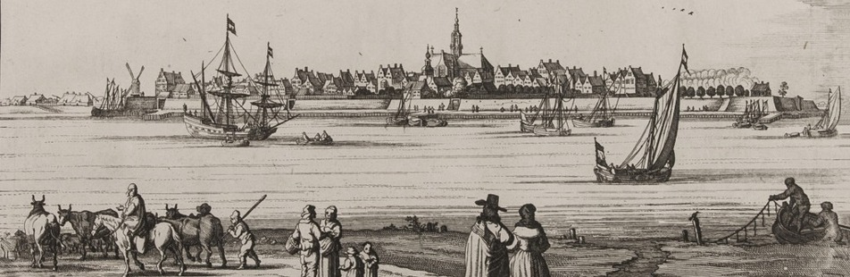
King William III of England's Dutch palace and gardens

LETH, Hendrik de. [Views of the Dutch royal estate Soestdijk].
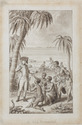
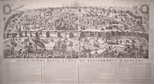
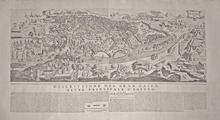
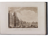
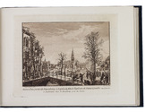
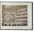
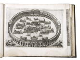
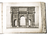
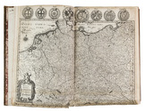
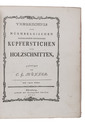
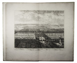
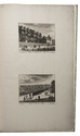
[Amsterdam], Hendrik de Leth, [ca. 1731]. Royal folio (55 x 34 cm). With large double-page general bird's-eye view of the Dutch royal estate Soestdijk (image size 35 x 47 cm) by B. Stoopendaal after B. Stuyvenburgh, and 16 numbered engraved views of details of the palace, gardens and other buildings (image size 12 x 16 cm) printed on 8 leaves. Modern half parchment. Full description
€ 4,750
Order Inquire Terms of sale

Drawing of a scene on the Coromandel Coast for an engraving in a book by Johann Georg Jacobi

[COROMANDEL COAST]. LIPS, Johann Heinrich. Die Küste Coromandel.
[Zürich, 1803]. Pen drawing (10.3 x 6.3 cm) in grey ink with washes on paper (12.5 x 8.5 cm), signed by the artist in the lower right corner of the illustration and with the title in pencil in the lower margin. The whole mounted on a larger paper leaf (with notes: "dessin no 522" and "Lips f." in ink), with a passepartout and in a gilt wooden frame. Full description
€ 6,500
Order Inquire Terms of sale

Charming aquatints of Dutch historical monuments and folklore

[MAASKAMP, Evert (editor)]. Merkwaardige gezigten, gebouwen, monumenten en standbeelden in de noordelijke provintien van het Koningrijk der Nederlanden. | Vues remarquables, edifices, monumens et statues dans les provinces septentrionales du Royaume des Pays-Bas.
Amsterdam, Evert Maaskamp, 1816. Oblong 8vo. With an engraved illustration on title-page and 37 sepia aquatints by Ludwig Portman after Gerrit Jan Michaëlis, Franciscus Aandreas Milatz, and Cornelius Overman. Contemporary gold-tooled dark blue boards. [40] ll. + 37 plates. Full description
€ 1,750
Order Inquire Terms of sale

Fine collection of 16th-century Italian cartography from the school of Antonio Lafreri

[LAFRERI - DUCHETTI - FLORINI - MAPS AND ENGRAVINGS - ITALY]. [Large album with 16th-century maps and engravings of Italy].
[Italy, late 16th and early 17th century]. Large oblong folio (ca. 59 x 42.3 cm). With 76 full-page engravings, and 12 full-page etchings. 17th-century gold-tooled brown calf, sewn on 6 supports with the corresponding raised bands on the spine, a red morocco title label on the spine with the title "Novissim[a] urbis Romae descript[io]" lettered in gold, gold-tooled board edges. Full description
€ 150,000
Order Inquire Terms of sale

One of the greatest printing enterprises of the 17th century

MERIAN, Matthäus. Theatrum Europaeum. Beschreibung aller Geschichten so sich 1617[-1718] zugetragen haben.
Frankfurt am Main, Daniel Fievet, Johann Görlin et al., ca. 1633-1738. 21 vols. Folio (ca. 22 × 33.5 cm). With 19 (of 20) engraved title-pages, 1 engraved title vignette, 1 armorial plate, 646 (of 686) engraved views, plans, and maps, many folding or double-page-sized, 690 (of 692) engravings in the text (mostly portraits on interleaves), and several folding tables. Early 18th century full leather bindings with gold-tooled spines (titles and crown crest) and blind-tooled frame on the boards; slightly differing from vol. 16 onwards with gilt supralibros "Academ. Marburg.". Full description
€ 75,000
Order Inquire Terms of sale

A famous topography of Switzerland enlarged with 68 extra engravings

MERIAN, Matthäus. Topographia Helvetiae Rhaetiae et Valesiae. Das ist, Beschreibung und eigentliche Abbildung der vornembsten Stätte und Plätz, in der hochlöblichen Eydgnoßschafft, Grawbündten, Walliß, und etlicher zugewanten Orten.
[Frankfurt am Main], Matthäus Merian, 1642. Folio. With richly engraved title-page, 74 (of 76) engraved maps, plans and views on 54 (of 56) plates normally included the 1642 first edition (nearly all double-page) plus 1 large folding plate from the 1653 Anhang, and 67 additional engravings from the 17th and 18th century, including at least 16 by or after Merian. Altogether there are 3 general maps (1 of Germany and surroundings and 2 of Switzerland), 4 detail maps, and numerous city plans and views. Lacking the bird's eye view of Herisau and the second of two views of Neuchâtel. Tanned sheepskin (ca. 1700?), gold-tooled spine. 72, [8] pp. plus engraved plates. Full description
€ 29,500
Order Inquire Terms of sale

Enormous panoramic Middle Eastern view with ruins, nearly 6 metres long

[VIEW - MIDDLE EAST]. [Mountainous landscape with Middle Eastern and classical Roman ruins, 6 shepherds with their flocks, several figures riding dromedaries and one riding a donkey, (date?) palms, lakes, etc.].
[Palestine?, ca. 1910?]. An enormous panoramic view drawn in coloured gouaches on a single, continuous roll of paper (70 x 583 cm), the drawing running to the edges of the paper. Full description
€ 35,000
Order Inquire Terms of sale
97 books found / Show all