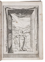

Splendid large watercolour view of ruins in Sicily
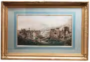
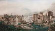
[CASSAS, Louis Francois].
[View of the Taormina theatre ruins (Sicily) with Mount Etna in the distance].
[Sicily or Paris], [ca. 1781 or somewhat later?]. 46 x 81 cm (frame 85 x 128 cm). Watercolour with pencil outlines and highlighted with white, laid in on paper pasted on wood.With a later blue and gold passe-partout in a contemporary gilt frame. Full description
€ 25,000
[Sicily or Paris], [ca. 1781 or somewhat later?]. 46 x 81 cm (frame 85 x 128 cm). Watercolour with pencil outlines and highlighted with white, laid in on paper pasted on wood.With a later blue and gold passe-partout in a contemporary gilt frame. Full description