
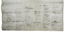
The most important British citizens of Madras gathered in one document
STEEL, Scudamore Winde (subject).
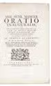
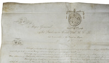
To Major General Sir Scudamore Winde Steel K. C. B. late commander of the forces in Pegue &c ....
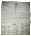
Madras, 10 April 1856. Manuscript in ink on a large single sheet of vellum (ca. 62 x 73 cm). With the hand drawn coat-of-arms of Scudamore Winde Steel in ink at the head of the text and with 106 signatures of British residents of Madras at the foot of the text. Folded. [1] leaf. Full description
€ 3,500
Madras, 10 April 1856. Manuscript in ink on a large single sheet of vellum (ca. 62 x 73 cm). With the hand drawn coat-of-arms of Scudamore Winde Steel in ink at the head of the text and with 106 signatures of British residents of Madras at the foot of the text. Folded. [1] leaf. Full description