
Letter by famous Scottish explorer of the Korean coasts and parts of China
HALL, Basil.
[Autograph letter, signed, to Aaron Louis Frédéric Regnault, Baron de la Susse].
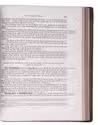
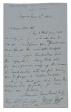
Smyrna (Izmir, Turkey), 27 June 1842. 8vo (18 x 11 cm). Manuscript letter in English, in brown ink on one side of an 8vo double leaf. Signed at the foot by Basil Hall. [1], [3 blank] pp. Full description
€ 850
Smyrna (Izmir, Turkey), 27 June 1842. 8vo (18 x 11 cm). Manuscript letter in English, in brown ink on one side of an 8vo double leaf. Signed at the foot by Basil Hall. [1], [3 blank] pp. Full description