Categories
Shopping cart (0 items € 0)
Advanced search

Cartography, Exploration & Voyages

First edition of the magnificent work on the Dutch colony of Brazil,
the folio edition, complete with all plates and maps

BARLAEUS, Caspar. Rerum per Octennium in Brasilia et alibi nuper gestarum.
Amsterdam, Joan Blaeu, 1647. Folio. With an engraved title page, an engraved portrait of Johan Maurits van Nassau, 25 double-page engraved maps and plans, and 31 double-page engraved plates. Further with a woodcut printer's device on the title page. Contemporary vellum, upper cover ruled in blind with blind-stamped floral vignette in center. [12, including title-page, frontispiece and portrait], 340, [8] pp. Full description
€ 36,500
Order Inquire Terms of sale

Dutch edition of Barrow's Travels in China

BARROW, John. Reizen in China, ...
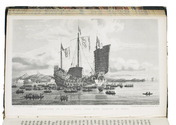
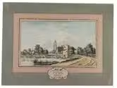
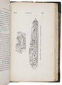
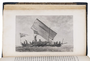
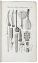
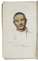
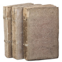
Haarlem, François Bohn, 1807-1809. 3 volumes. 8vo. With 10 engraved plates (6 folding, 1 double-page), the double-page plate with 2 portraits hand-coloured, 4 leaves with engraved music, and several woodcut and engraved illustrations in the text. Original publisher's boards. VIII, 288; VI, 334; VI, 341, [1] pp. Full description
€ 950
Order Inquire Terms of sale

Illustrated edition of Beechey's famous Pacific voyage, including an Eskimo vocabulary

BEECHEY, Frederick William. Narrative of a voyage to the Pacific and Beering's Strait...
London, Henry Colburn & Richard Bentley, 1831. 2 volumes. Large 8vo. With 3 lithographed maps (2 large folding), 20 engraved plates, 3 two-page folding plates, and 1 engraved illustration in the text. Contemporary half green morocco, marbled sides, gold-tooled title on spine, marbled edges. XXVI, [1], [1 blank], 472; IV, 330, [1], 331-452 pp. Full description
€ 1,250
Order Inquire Terms of sale

Very rare map of North Holland in 1575

BEELDSNIJDER, Joost Jansz. Vernieuwde Kaart van Noordholland en Westfriesland, benevens het voornaamste gedeelte van Rhynland, en daar aan grenzende Landen.
Amsterdam, Yntema & Tieboel, 1778. (92 x 68 cm). Large hand-coloured engraved map on 2 sheets, decorated with arms, figures and products from the regions shown, and with the title at the foot. Framed. Full description
€ 7,250
Order Inquire Terms of sale

Rare historical travel account through France profusely illustrated with city views

[BEER, Johann Christoph]. Ausführliche und grundrichtige Beschreibung deß Königreichs Franckreich. Welcher Gestalt nemlich selbiges in 12. Haupt-Theile, oder Provintzien und Gouvernementen eingetheilet wird ... was vor Städte, Schlösser und Vestungen darinnen befindlich ... Alles durch Beyhülffe bewährter Scribenten vorgestellet.
Frankfurt and Leipzig, Christoph Riegel, 1689. 12mo. With a folding engraved frontispiece, and 116 (4 folding, 112 full-page) engraved bird's eye views of French cities. Contemporary gold- and blind-tooled pigskin, sewn on 3 supports with the corresponding raised bands on the spine, a manuscript shelf mark on the spine, a central ornament on both boards surrounded by a floral border, the initials "M Z" and year "1690" lettered in gold on the front board, remnants of clasps, dark blue edges. [6], 1095, [17] pp. Full description
€ 2,000
Order Inquire Terms of sale

An important surveying voyage to the Pacific

BELCHER, Edward. Narrative of a voyage round the world, performed in Her Majesty's ship Sulphur, during the years 1836-1842, including details of the naval operations in China, from Dec. 1840 to Nov. 1841.
London, Henry Colburn, 1843. 2 volumes. 8vo. With a folding map of the Canton river, folding map with the routes of the H.M.S. Sulphur, large world chart also showing the route of the Sulphur, 19 steel-engraved views and several illustrations in text. Gold-tooled blue sheepskin, shell-marbled sides. Rebacked. In modern slipcase. XXII, 387; VI, 474 pp. Full description
€ 2,950
Order Inquire Terms of sale

Belon's account of his extensive travels in the Levant, with 44 woodcut illustrations

BELON, Pierre. Les observations de plusieurs singularitez et choses memorables, trouvées en Grece, Asie, Judée, Egypte, Arabie et autres pays estranges.
Paris, Guillaume Cavellat (colophon: printed by Benoist Prévost for Gilles Corozet, Guillaume Cavellat), 1555. 3 parts in 1 volume. 4to. With title in woodcut border with Cavellet's device and initials at the foot, each part-title with Cavellet's woodcut device, 1 folding woodcut map (31.5 x 35 cm) showing Mount Sinai, 44 woodcuts in the text (including a portrait of the author by Geoffroy Tory), and numerous fine decorated initials. Overlapping vellum (ca. 1600?). [12], 212, [1] ll. Full description
€ 12,500
Order Inquire Terms of sale
702 books found / Show all