Categories
Shopping cart (0 items € 0)
Advanced search

Cartography, Exploration & Voyages

First edition of the history and description of Enkhuizen

[BRANDT, Gerard]. Historie der vermaerde zee- en koop-stadt Enkhuisen, vervaetende haere herkomste, en voortgangh. Mitsgaders verscheide gedenkwaerdige geschiedenissen, aldaer voorgevallen.
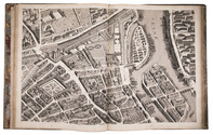
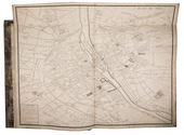
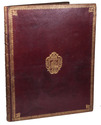
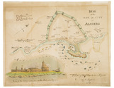
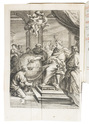
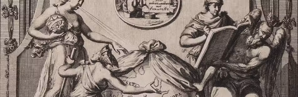
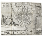
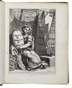
Enkhuizen, Egbert van den Hoof, 1666. 4to. With the woodcut coat of arms of Enkhuizen on the title page, an engraved allegorical frontispiece by H. Bary, 5 full-page engraved portraits by H. Bary, a large folding plan of Enkhuizen after design by O. Suermondt, and a large folding plate with 31 coats of arms of the members of the city council. Contemporary sheepskin parchment. [12], 207, [1], 167, [1 blank], [16] pp. Full description
€ 1,950
Order Inquire Terms of sale

The greatest map of Paris, 240 x 316 cm, here with the 20 sheets and key map bound as an atlas
in contemporary gold-tooled morocco with the Paris city arms

BRETEZ, Louis. Plan de Paris commencé l'année 1734. Dessiné et gravé, sous les ordres de Messire Michel Etienne Turgot, Marquis de Sousmons ... Achevé de graver en 1739.
[Paris, 1739]. Grand-Aigle folio (56 x 45.5 cm). An enormous engraved map of Paris in 20 numbered sheets plus a key map, at a scale of about 1:2000, each segment measuring 55 x 84 cm (plate size 51.5 x 80.5 cm; image 48 x 79 cm) which would give an assembled map with image size about 240 x 316 cm! The key map is slightly larger than the segments and folds out at the head. Bound as an atlas (but with segments 18 and 19, containing the cartouche, assembled to make a long fold-out) in contemporary gold-tooled red morocco, each board with as centrepiece the Paris coat of arms (a ship with chief a field of fleurs-de-lis). Full description
€ 15,000
Order Inquire Terms of sale

An expedition to the South African interior: "of great permanent worth",
together with a description of the Cape of Good Hope

[BRINK, Carel Frederik]. Nouvelle description du Cap de Bonne-Espérance, avec un Journal historique d'un voyage de terre, . . . , dans l'intérieur de l'Afrique. . . . Sous le commandement du Capitain Mr. Henri Hop, . . .
Amsterdam, J.H. Schneider, 1778. 2 parts in 1 volume. 8vo. Title-page with an engraved vignette by Christian Friedrich Fritzsch and 16 folding engraved plates. Olive half calf (ca. 1840), gold-tooled spine. [6], 130, [2], 100 pp. Full description
€ 3,950
Order Inquire Terms of sale

France elaborately mapped: a famous and rare atlas including key maps for travellers

BRION DE LA TOUR, Louis & Louis Charles DESNOS. Coup d'oeil général sur la France, pour servir d'introduction au tableau analytique et géographique de ce Royaume. Dressé par différens géographes, dont les ouvrages sont aussi connus qu'estimés, faisant partie de l'atlas historique de la France ancienne & moderne ...
Paris, Grangé, Guillyn, Desnos, et al., 1765. 2 works in 1 volume, the first in 3 parts. 4to. With a double-page frontispiece by Le Charpentier after De Sève, with a view of the Place de la Concorde in Paris, 2 large folding engraved maps of France by Rizzi Zannoni, 40 double-page engraved maps and charts of France, 10 folding road maps, 2 "Cartes odographiques" with the distances between French cities, and 3 double-page engraved part-titles, all but the frontispiece and titles in a contemporary hand colouring.
Comprising: (2) DESNOS, Louis Charles. Tableau analytique de la France.
Paris, chez l'auteur, 1765.
(3) ZANNONINI, Rizzi. Le petite Neptune François ou carte des côtes maritimes du Royaume.
Paris, chez le Sr. Desnos, 1765.
(4) MICHEL. L'indicateur fidèle ou guide des voyageurs.
Paris, à l'enseigne du globe, 1765.
With: (5) [CATALOGUE]. Catalogue des Ouvrages, tant anciens que modernes, du Fonds du Sr. Desnos.
Paris, à l'enseigne du globe et de la sphere, 1765. Contemporary gold- and blind-tooled marbled calf. 15, [1 blank], [3], [1 blank], 8, 10; 16 pp. + 56 plates Full description
€ 3,250
Order Inquire Terms of sale

Hand coloured battle plan for the 1816 attack on Algiers

[BRITISH NAVY - BATTLE PLAN - ALGIERS]. Plan of the Bay and City of Algiers.
[London?, 1816]. 35 x 44. With an illustration of the plan of attack and a view of the fortifications on the Mole at Algiers. Full description
€ 1,750
Order Inquire Terms of sale

Appealing wall map of the Slaperdijk in the Gelderse Vallei

[MAP - NETHERLANDS - GELDERSE VALLEI]. BROECKHUIJSEN, Justus van. Caarte vanden Slaperdijk streckende vande Stichtse bergen tot aan de hoogte van Gelderland.
Utrecht, Slaperdijk Managing Board ("College tot Directie van de Slaperdijk"), (engraved:) 1705. Engraved wall map printed on 8 sheets (measuring: 76 x 194 cm as assembled) by Caspar Specht after Justus van Broeckhuijsen (scale ca. 1:5600). Framed (107 x 220 cm). Full description
€ 12,500
Order Inquire Terms of sale

3 little-known works by Italian scientist on astronomy, hydrostatics and navigation

BRUNETTI, Francesco Saverio. Trattenimenti scientifici su la sfera, geografia istorica, meteore, ed astronomia.
Rome, Bernabò and Lazzarini, 1754. With several woodcut illustrations in the text (including an armillary sphere), and an extra added folding engraved frontispiece.
With:
(2) BRUNETTI, Francesco Saverio. Trattenimenti scientifici su lindrografia, nautica, blasone, statica, meccanica, architectura, pirotecnia, e suono.
Roma, Bernabò and Lazzarini, 1755. With several woodcut illustrations in the text, and an extra added frontispiece (facsimile of an engraving?).
(3) BRUNETTI, Francesco Saverio. Macchina semplicissima per cui lacqua da se stessa salice ad una data altezza.
Rome, Bernabò and Lazzarini, 1747. With folding engraved plate as frontispiece. 3 works (the first in 2 parts) in 1 volume. 4to. Contemporary sheepskin parchment. [24], 180, 112; [8], 173, [3 blank]; 12 pp. Full description
€ 4,500
Order Inquire Terms of sale
702 books found / Show all