Categories
Shopping cart (0 items € 0)
Advanced search

Cartography, Exploration & Voyages / Atlases, Charts, Maps & Globes

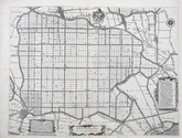
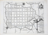
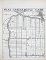
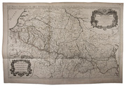
Rare wall map of the Gooi, coloured by a contemporary hand

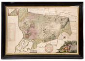
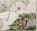
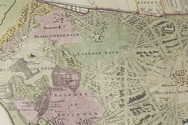
[MAP - HET GOOI]. POST, Hendrik. Nieuwe kaart van Gooilandt word met schuldige eerbiedigheidt aan den wel. ed. gestr. Heere en Mr. Henrick Bicker schepen der stadt Amsterdam, raadt en advt. fiscaal ter Admiraliteit aldaar meestersknaap van Gooilandt, enz, enz. opgedragen door Reinier & Josua Ottens.
Amsterdam, Reinier & Josua Ottens. [ca. 1737]. 52.5 x 82 cm. Framed. Full description
€ 28,000
Order Inquire Terms of sale

Collection of 6 maps of the Beemster polder 1644-1979

[MAP - NETHERLANDS - BEEMSTER]. FLORISZ. VAN BERCKENRODE, Balthasar and Daniel van BREEN. Beemsterlants caerte... [with a second title at the head:] Ware afbeeldinge vande bedyckte Beemster-landen... M.DC.XLIIII.
Amsterdam, 1644 [reprinted ca. 1769?].
And:
(2) [FLORISZ. VAN BERCKENRODE, Balthasar] and Daniel van BREEN. Beemsterlants caerte...
Amsterdam, 1658. Engraved map (43.5 x 58 cm).
(3) [MAP - NETHERLANDS - BEEMSTER]. Beemster landts kaarte, aenwijsende de hoogte vande ringhdyck. Als mede de diepte vande tocht & wech slooten.
[Amsterdam(?), ca. 1696].
(4-5) DORLAND, C. [2 maps of the Beemster].
Amsterdam, Tresling & Co., March 1908.
(6) [MAP - NETHERLANDS - BEEMSTER]. Waterschap de Beemster.
February 1970, updated to 1979. Large map (64 x 50 cm).
Collection of 6 maps (the first in 6 sheets). Engraved map in 6 sheets (each 56 x 44 cm). With the main title in a large cartouche at right, the statement about its production and a scale of Rijnland rods in a pedestal at the foot, a Latin verse in praise of the Beemster polder by Caspar van Baerle at lower right, a compass rose at upper right, and the arms of Beemster at the head. Bound in modern cloth (57.5 x 47 cm). Full description
€ 3,750
Order Inquire Terms of sale

Large map of the Pyrenees

[MAP - PYRENEES]. SANSON, Nicolas. Les Monts Pyrenées, ou sont remarqués les Passages de France en Espagne.
Paris, Hubert Jaillot, 1719. Engraved map on 2 assembled sheets (54.5 x 88 cm). With title in decorated cartouche (signed F.C.) in upper right corner and scalebars in decorated cartouche in the lower left corner. Coloured in outline. Full description
€ 500
Order Inquire Terms of sale

Large map of Spain and Portugal

[MAP - SPAIN & PORTUGAL]. SANSON, Nicolas. l'Espagne divisée en tous ses royaumes et principautés suivant qu'ils sont compris sous les Couronnes de Castille et d'Aragon, possedees par le Roy Catholique et sous la couronne de Portugal possedee par le Roy de Portugal.
Paris, Hubert Jaillot, [1708]. Engraved map on 2 assembled sheets (55.5 x 78 cm), engraved by Cordier. With title in decorated cartouche on the bottom right corner, scales and privilege in decorated cartouche on the bottom left corner, and a few lines coloured in green. Full description
€ 650
Order Inquire Terms of sale

Early atlas of the Dutch East Indies, with 60 large and detailed maps

MELVILL VAN CARNBEE, Pieter and Willem Frederik VERSTEEG. Algemeene atlas van Nederlandsch Indië. Uit officieele bronnen en met goedkeuring van het gouvernement zamengesteld.
Batavia (Jakarta, Indonesia), Van Haren Noman & Kolff, 1853-1862. Oblong folio (39.3 x 50.5 cm). With 60 lithographed maps, coloured in outline, and 3 lithographed index maps. Contemporary blind-tooled half black morocco. [68] ll. Full description
€ 1,850
Order Inquire Terms of sale

Field guide for officers during the Mesopotamian campaign (1914-1918), with a folding map

[MESOPOTAMIA]. [Indian Army General Staff]. For official use only. Field notes. Mesopotamia. General staff, India. February 1917.Including: Index to field notes, Mesopotamia, 1917.
Calcutta, Superintended government printing, 1917. Small 8vo. With 1 folding heliozincographed map of "Lower Mesopotamia", with some routes in red, and three folding letterpress tables. Original green cloth. [3], [1], 326(=325), [1]; [1], [1 blank], XX pp. Full description
€ 6,500
Order Inquire Terms of sale

Highly detailed maritime atlas

GREAT BRITAIN METEOROLOGICAL OFFICE. Monthly current charts for the Indian Ocean. From information collated & prepared in the Meteorological Office.
London, Admiralty Hydrographic Office, under the superintendence of Rear-Admiral W. J. L. Wharton, 1895-1896. Plano. Oblong Royal 1mo (full-sheet leaves: 51 x 62 cm). An atlas of 12 large black and white nautical charts. Limp cloth with gold-tooled title on front cover. [12] ll. plus the 1-page “Advertisement”. Full description
€ 3,500
Order Inquire Terms of sale

The first contemporary history of the Netherlands. In the first Latin edition, with a rare portrait of the author

METEREN, Emanuel van. Historia Belgica nostri potissimum temporis Belgii sub quatuor Burgundis & totidem Austriacis principibus coniunctionem & gubernationem breviter. Turbas autem, bella et mutationes tempore regis Philippi, Carli V. Caesaris filii, ad annum usque 1598. plenius complectens, conscripta.
[Cologne, A. Mylius, 1598]. Folio. With letterpress title-page in engraved border with scenes of trade and war (Verduyn, pl. XIV), additional engraved medallion portrait of the author mounted on blank back of title-page, by Hendrik Hondius the Elder, double-page engraved map of the Netherlands, by Frans Hogenberg and 22 engraved portraits on 19 plates. Contemporary vellum. [8], "623" [= 643], [1] pp. Full description
€ 2,000
Order Inquire Terms of sale
153 books found / Show all