Categories
Shopping cart (0 items € 0)
Advanced search

Cartography, Exploration & Voyages / Atlases, Charts, Maps & Globes

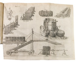
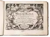
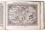
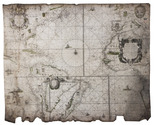
Well-illustrated encyclopaedia of astronomical and surveying instruments from the time of Galileo,
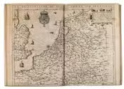
with a world map in two hemispheres, and 3 volvelles

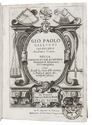
GALLUCCI, Giovanni Paolo. Della fabrica et uso di diversi stromenti di astronomia, et cosmografia, ove si vede la somma della teorica, et pratica di queste due nobilissime scienze.
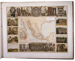
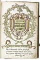
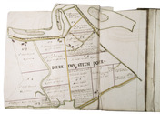
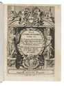
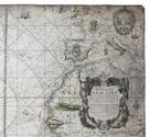
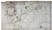
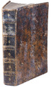
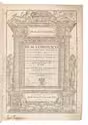
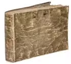
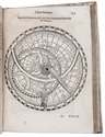
Venice, Roberto Meietti, 1598. 4to (22 x 16.5 cm). With engraved title-page, folding woodcut plate, 3 woodcut volvelles with moving parts, and numerous woodcut illustrations in text. Including a world map in two hemispheres (incl. America and a scattering of islands at the location of Australia) on two facing pages, they reappear with volvelle attachments on both sides of leaf 149 and leaf 153. Contemporary limp sheepskin parchment. [8], 228 ll. Full description
€ 35,000
Order Inquire Terms of sale

A Portuguese expedition to the Kingdom of Kazemba

GAMITTO, Antonio Candido Pedroso. O Muata Cazembe e os povos Maraves, Cheva, Muiza, Muembas, Lundas e outros da Africa austral.
Lisbon, Imprensa Nacional, 1854. 8vo. With 22 hand-coloured lithographed plates, and a folding lithographed map (45 x 28 cm), hand-coloured in outline. Contemporary straight-grained, gold-tooled black sheepskin, gilt edges. XXV, [1 blank], 501, [1 blank], [2] pp. Full description
€ 9,000
Order Inquire Terms of sale

Mexico in the 1880s, with atlas volume including 13 chromolithographed maps and 1 general map of Mexico

GARCIA CUBAS, Antonio. Cuadro geográfico, estadístico, descriptivo é histórico de los estados unidos Mexicanos. Obra que sirve de texto al Atlas pintoresco.
Including: Atlas Pintoresco e Historico de los Estados Unidos Mexicanos.
México, Fomento & Debray, 1885. 2 volumes. 8vo and oblong large folio (64.5 x 82 cm). With 2 folding tables and 2 full-page plates in the text volume and in the atlas 13 chromolithographed maps (52 x 69 cm), and a full-page chromolithographed map of Mexico at the end. Contemporary black cloth with gold lettering on front board (text); contemporary red half morocco, title and ornaments in gold on spine (atlas). IV, 474, [3] pp. text. Full description
€ 11,000
Order Inquire Terms of sale

Manuscript atlas and ownership records of parcels in the Prins Willem polder,
northeast of Oostburg, in the southwest corner of the Netherlands

GERSOM, Gerrit van. Caerte en omlooper van Prins Willem Polder. Bedijkt anno 1650 en 1651. ...
[Oostburg?], 1723. Royal folio (41 x 27.5 cm). With a hand-coloured title page, a large folding map of the dikes along the border of the polder, a large folding general map of the polder showing the numbered parcels at a scale of about 1:18,000, and 17 folding detail maps showing the individual plots within the parcels at a larger scale, all executed in brown ink and watercolours and tipped onto the fore-edges of 19 of the 144 numbered text leaves. Contemporary sheepskin parchment. 151 ll. (ll. 1 & 145-151 blank). Full description
€ 9,500
Order Inquire Terms of sale

A general in the Spanish army on the battles and sieges in Flanders 1601-1609,
during the Dutch war for independence, with 29 folding maps and plans

GIUSTINIANO, Pompeo. Delle guerre di Flandra libri VI. ... Posti in luce da Gioseppe Gamurini ...
Antwerp, J. Trognesio, 1609. 4to. With engraved architectural title-page and 29 folding engraved maps and plans of sieges and fortifications. White sheepskin (ca. 1700 or possibly later). [4], 329, [1 blank], [15], [3 blank] pp. Full description
€ 2,950
Order Inquire Terms of sale

A pair of striking Victorian library globes by map-maker George Frederick Cruchley

[GLOBES - TERRESTRIAL & CELESTIAL]. CRUCHLEY, George Frederick. Cruchley's new terrestrial globe from the most recent and best authorities, exhibiting the discoveries in equatorial Africa, North Pole, and the new settlements and divisions in Australia, New Zealand, California, Texas &c.
London, George Frederick Cruchley, [ca. 1850].
With: CRUCHLEY, George Frederick. Cruchleys new celestial globe on which is accurately laid down the whole of the stars and nebule contained in the astronomical catalogue of the Reverend Mr. Wollaston F.R.S. Also from the authorities Flamstead, De la Caille, Hevellus, Bradley, Herschel, Maskelyne, &c. and the limits of each constellation determined by a boundary line.
London, George Frederick Cruchley, [ca. 1850].
A matching pair of terrestrial and celestial globes (53 cm diameter) each made a hollow paper-marché core (2 hemispheres, joined at the equator), covered with a layer of plaster and 12 hand-coloured, engraved gores, showing the terrestrial geography and celestial bodies in great detail. Each globe mounted in a mahogany tripod stand on small wheels. With a compass (diameter: 25 cm) at the base of each stand; graduated brass meridian ring and engraved graduated horizontal rings (paper pasted on the mahogany frame) showing the months of the year, the zodiac signs and wind directions. Full description
€ 97,500
Order Inquire Terms of sale

The only atlas published by Abraham Goos: the 17 provinces of the Habsburg Low Countries

GOOS, Abraham. Nieuw Nederlandtsch caertboeck. Waer in volkomentlijcker als oyt te voren vertoont werden de XVII. Nederlanden, soo in t geheel, als elck besonder met grote neersticheyt ende kosten gesneden ende in t licht gebracht. Mitsgaders een nieuwe beschryvinge uijt verscheyden autheuren ordentlyck tsamen gestelt door Reinier Telle ... .
Amsterdam, Abraham Goos in de Kalverstraet, [1616]. Oblong 4to (ca. 16 x 21 cm). With an engraved title page (signed by P.S[erwouter] scul. (bottom right) after D.V[inck] B[oons] (bottom left)), 23 full page maps, several decorated woodcut initials and woodcut tailpieces. 19th-century quarter calf. [7], "305" [=294], [2], [1 blank] pp. Full description
€ 4,500
Order Inquire Terms of sale

Goos' West-Indische paskaert in its very rare first state: a monumental nautical chart of the Atlantic Ocean in Mercator projection on vellum, used by the Dutch West Indian Company (WIC)

GOOS, Pieter. West-Indische Paskaert waer in de graden der breedde over wederzijden van de middellijn wassende so vergrooten dat die geproportioneert sijn tegen hunne nevenstaende graden de lengde. Vertonende behalve[n] Europaes zuydelijcste alle de zeekusten van Africa en America begrepen in 't Octroy bij de H.M.H. Staten Generael der vereenichde Nederl. verleent aende Generale West Indische Compagnie. Mitsgaders die van Peru en Chili inde groote Zuyd-Zee.
Amsterdam, Pieter Goos, [ca. 1660]. Printed on vellum (ca. 80 x 98 cm) from one large copperplate engraving, partly coloured by a contemporary hand. Full description
€ 185,000
Order Inquire Terms of sale

Italian fortification atlas of the Low Countries

GUALDO PRIORATO, Galeazzo. Teatro del Belgio ò sia descritione delle diecisette provincie del medesimo; con le piante delle città, e fortezze principali; da chi al presente possesse; come, in qual modo, & in qual tempo acquistate.
Vienna, Michael Thurnmayer, 1673. Folio. With engraved frontispiece with the coat-of-arms of all Seventeen Provinces, engraved military scene on the title-page, folding engraved map of the Low Countries, 2 folding engraved views of a sea-battle and an army crossing the Rhine, and 120 double-page engraved fortification plans. Contemporary mottled sheepskin, gold-tooled spine. [14], 148, [6] pp. text Full description
€ 5,000
Order Inquire Terms of sale

First edition of Guicciardini's celebrated description of the Low Countries

GUICCIARDINI, Lodovico. Descrittione ... di tutti i Paesi Bassi, altrimenti detti Germania Inferiore.
Antwerp, Willem Silvius, 1567. Folio. With the title, the large coat of arms of Philip II, and his portrait set within a woodcut architectural frame with allegorical figures on separate pages, and 17 double-page plates, maps and views (15 woodcuts, 2 engravings).Further with 15 woodcut divisional title-pages for the illustrations and descriptions of the regions and cities set within a woodcut ornamental frame and numerous woodcut decorated initials (at least 4 series). Later vellum. [3], [1 blank], [16], "296"[= 339], [1 blank], [19], [1 blank] pp. Full description
€ 8,000
Order Inquire Terms of sale
153 books found / Show all