
Beautiful 18th-century view of Leiden
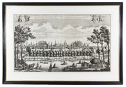
[VIEW - NETHERLANDS - LEIDEN]. SCHENK, Leonardus [and Abraham RADEMAKER].
Gesigt van de stadt Leyden beroemt door syn hooge schoole geleege in Holland op den verstopten Ryn. | Vue de la ville de Leide fameuse par son academie située en Hollande sur le Rhin bouché.
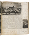
[Amsterdam], Leonardus Schenk, [ca. 1728/36]. Large engraved wall print on 2 sheets (together 57.5 x 97 cm) showing the Leiden city wall between the Koepoort and Zijlpoort, with various windmills and prominent buildings in the background identified by name. The title appears in a banderole at the head, with putti on either side holding the arms of Leiden and Holland. Leonardus Schenk's name appears as engraver and publisher at the right end of the banderole. Framed (82.5 x 121 cm). Full description
€ 8,500
[Amsterdam], Leonardus Schenk, [ca. 1728/36]. Large engraved wall print on 2 sheets (together 57.5 x 97 cm) showing the Leiden city wall between the Koepoort and Zijlpoort, with various windmills and prominent buildings in the background identified by name. The title appears in a banderole at the head, with putti on either side holding the arms of Leiden and Holland. Leonardus Schenk's name appears as engraver and publisher at the right end of the banderole. Framed (82.5 x 121 cm). Full description