Categories
Shopping cart (0 items € 0)
Advanced search

Maritime History / Navigation

Updated edition of a massive directory providing essential information
for navigating in the Southern and Eastern hemispheres

HORSBURGH, James. The India directory, or, directions for sailing to and from the East Indies, China, Australia, and the interjacent ports of Africa and South America ... Seventh edition.
London, Wm. H. Allen & Co. (back of the title pages: printed by Cox and Wyman), 1855. 2 volumes. Large 4to (28 x 23 cm). Contemporary half calf, re-backed with the original backstrips laid down. XII, XXXIV, [2], “681” [= 683], [1 blank]; VIII, 978 pp. Full description
€ 18,000
Order Inquire Terms of sale

Important guide to navigating the seas to the far reaches of Asia

HUDDART, Joseph. 
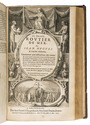
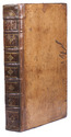
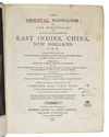
The oriental navigator; or, new directions for sailing to and from the East Indies, China, New Holland, &c. &c. &c. Also for the use of the country ships, trading in the Indian and China seas, Pacific Ocean, &c. &c. &c...
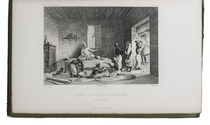
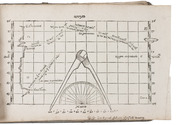
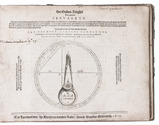
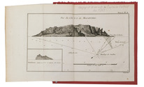
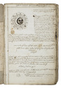
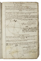
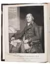
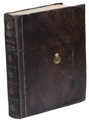
London, printed and published by Robert Laurie and James Whittle, map, chart, and printsellers, 1801. 4to. With an engraved frontispiece portrait of Huddart by James Stow after John Hoppner and small woodcut coastal views in the text. Contemporary tree calf. [2], XII, 656 pp. Full description
€ 7,500
Order Inquire Terms of sale

Navigating the coast of West Africa

KERHALLET, Charles-Marie Philippe de. Description nautique de la côte occidentale dAfrique depuis le Cap Roxo jusquaux Îles de Los, comprenant larchipel des Bissagos.
Paris, Paul Dupont, 1849. 8vo. Later half black cloth, with the title and year of publication lettered in gold on the front, the logo of the Royal Danish Navy library gold-tooled on the front, black and pink marbled paper sides. 102 pp. Full description
€ 1,500
Order Inquire Terms of sale

A valuable account of the Greek islands, with a large folding chart

[KINSBERGEN, Jan Hendrik van]. Beschryvinge van den archipel, tot nut van den krygsman, zeevaarenden en handeldryvenden.
Amsterdam, 1792. 8vo. With a large folding engraved sea chart (57.5 x 68.5 cm). Publisher's original flexible boards covered with blue paper, with the title and decoration printed letterpress on the spine. [8], 190, [2 blank] pp. Full description
€ 1,850
Order Inquire Terms of sale

Around the world in 1180 days, with 2 folding maps and 31 steel-engraved views

LAPLACE, Cyrille Pierre Théodore. Campagne de circumnavigation de la frégate l'Artémise, pendant les annéees 1837, 1838, 1839 et 1840, ... Tome premier[-sixième].
Paris, Arthus Bertrand, 1841-1854. 6 volumes. 8vo. With 2 large folding engraved maps and 31 steel-engraved views. With the maps coloured in outline or partly coloured, and with the routes indicated and coloured. Contemporary boards, covered with the publisher's original green printed paper. XXXIX, [1 blank], 343, [1 blank], [3], [1 blank]; [3], [1 blank], 467, [1 blank], [3], [1 blank]; [3], [1 blank], 548, [1], [1 blank]; [3], [1 blank], 464, [3], [1 blank]; [3], [1 blank], III, [1 blank], 542, [2]; [3], [1 blank], 400 pp. Full description
€ 22,500
Order Inquire Terms of sale

Battle of words over the best practical solution to the determination of longitude before Harrison's chronometer

LEY, Jan Hendrick Jarichs van der. Het gulden zeeghel des grooten zeevaerts, daerinne beschreven wordt de waerachtige grondt vande zeylstreken en platte pas-caerten ...
Leeuwarden, Abraham vanden Rade, 1615. Oblong 4to (16.5 x 22 cm). With an emblematic engraved device/navigational diagram on the title-page and 27 (of 28) woodcut figures: 18 printed on integral leaves and the others on 3 folding plates. 18th-century(?) half vellum, blue-green paper sides, with manuscript author and title on spine. 114, [2] pp. Full description
€ 55,000
Order Inquire Terms of sale

Opening the East for trade for the Dutch and the English

LINSCHOTEN, Jan Huygen van. Itinerario, voyage ofte schipvaert, ... naer Oost ofte Portugaels Indien ...
Amsterdam, Cornelis Claesz., [1595-] 1596.
With:
(2) IDEM. Reys-gheschrift van de navigatien der Portugaloysers in Orienten ...
Including: IDEM. Een seker extract ende sommier van alle de renten, domeynen, tollen, ... importen, trubuyten, thienden, derde-penninghen en[de] incomsten des coninghs van Spaengien ...
Amsterdam, Cornelis Claesz., 1596 [= 1595].
(3) IDEM. Beschijvinghe van de gantsche custe van Guinea, Manicongo, Angola, Monomotapa, ende teghen over de Cabo de S. Augustijn in Brasilien ...
Amsterdam, Cornelis Claesz., 1596. 4 parts in 1 volume. Small folio (ca. 31 x 21 cm). With 6 folding maps, 36 folding or double-page plates, a full-page author's portrait, and a large illustration on each of the 4 divisional title pages, all engraved. Contemporary blind-tooled vellum over modern boards (?), with the manuscript author, title, and year of publication on the spine, red and blue sprinkled edges. [8], 160; 134, [4], 135-147; [82], [2 blank], [8] pp. Full description
€ 110,000
Order Inquire Terms of sale

Influential guide to the East and West Indies, featuring 42 double-page and folding plates,
including 6 detailed maps.

LINSCHOTEN, Jan Huygen van. Histoire de la navigation... aux Indes Orientales. Contenant diverses descriptions des lieux jusques à present descouverts par les Portugais: observations de coustumes & singularitez de delà, & autres declarations. Deuxiesme edition augmentee.
Amsterdam, Evert Cloppenburg, 1619. 3 works in 1 volume, the first in 2 parts. Folio (31 x 21 cm) With an engraved title page for each work, 42 engraved plates (31 double-page and 11 folding), including 6 maps, and a full-page portrait of the author within collation. Including: LINSCHOTEN, Jan Huyghen van. Le grand routier de mer, ...
[LINSCHOTEN, Jan Huygen van]. Description de lAmerique & des parties dicelle ...
Near-contemporary gold-tooled calf. [1], [1 blank], [6], "205" [= 206]; [1], [1 blank], [2], 181, [1 blank]; [1], [1 blank], "86" [= 80]. Full description
€ 65,000
Order Inquire Terms of sale

Seminal guide to the East and West Indies, with 42 double-page and folding plates, including 6 maps, all engravings beautifully coloured by a contemporary hand

LINSCHOTEN, Jan Huyghen van. Histoire de la navigation ... aux Indes Orientales ... Avec annotations de B. Paludanus, ... Troixiesme edition augmentee.
Including:
LINSCHOTEN, Jan Huyghen van. Le grand routier de mer, ...
[LINSCHOTEN, Jan Huygen van]. Description de l'Amerique & des parties d'icelle, ...
Amsterdam, Evert Cloppenburg, 1638. Folio (32.5 x 21 cm). With 3 title pages (2 from the same full-page engraving and 1 letterpress with an engraving of a ship in a cartouche with 4 inset city views), a nearly full-page engraved portrait of the author in a cartouche with 4 inset views, 42 engraved plates including 6 maps (31 double-page & 11 larger folding). All plates coloured by a contemporary hand. Near contemporary mottled calf, gold-tooled spine. [8], 206 pp.; [4], 181, [1 blank]; [1], [1 blank], “86” [= 80], [2 blank] pp. Full description
€ 275,000
Order Inquire Terms of sale

Discovery of the Canary Islands in classical Greek and Roman, Arabic and Portuguese sources

MACEDO, Joaquim José da Costa de. Memoria em que se pertende provar que os Arabes não conhecerão as Canarias antes dos Portuguezes.
Lisbon, printing office of the Academia Real das Sciencias, 1844. Folio. With a woodcut Portuguese coat of arms on the title-page. Modern brown paper wrapper. [4], 232 pp. Full description
€ 1,500
Order Inquire Terms of sale
84 books found / Show all