Categories
Shopping cart (0 items € 0)
Advanced search

Americas / Cartography, Exploration, Travel & Voyages

Account of an interesting scientific expedition to Bolivia

ORBIGNY, Alcide d'. Fragment d'un voyage au centre de l'Amérique Méridionale; contenant des considérations sur la navigation de l'Amazone et de la Plata, et sur les anciennes missions des provinces de Chiquitos et de Moxos (Bolivia).
Paris, P. Bertrand; Strasbourg, widow Levrault (printed by Berger-Levrault), 1845. 8vo. With a large folding lithographed map (43 x 52 cm) of the centre of South America. Modern half red morocco. [4], 584 pp. Full description
€ 6,750
Order Inquire Terms of sale

From Rio de Janeiro to Batavia: a gripping account of the fastest circumnavigation of the globe of the time

ORTEGA, Casimiro de (translator), [Charles CLERKE (attributed)]. Viage del comandante Byron al rededor del mundo, hecho ultimamente de orden del almirantazgo de Inglaterra.
Madrid, Don Francisco Mariano Nipho, 1769. 4to. With a full-page, copper-engraved frontispiece, a large, folding, copper-engraved map of the Strait of Magellan in the back with the coasts highlighted in blue, and ornamental head-pieces throughout. Contemporary vellum with the manuscript title and a (later) shelf mark ("143") on the spine. [18], 245, [1 blank] pp. Full description
€ 6,500
Order Inquire Terms of sale

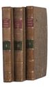
Journey through America in 1817, in Dutch translation
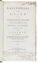
PALMER, John. 
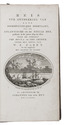
Dagverhaal eener reize in de Vereenigde Staten van Noord-America, en Neder-Canada, gedaan in 1817. Uit het Engelsch, met eene inleiding, bevattende een statistisch overzigt der Vereenigde Staten van Noord-America, volgens de beste en nieuwste berigten. Met eene nieuwe kaart.
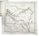
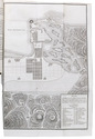
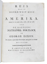
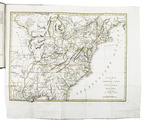
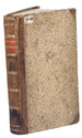
Haarlem, heirs of François Bohn, 1820. 8vo. With large folding map of America (34.5 x 44.5 cm), engraved by D. Veelwaard after John Melish, borders and outlines in contemporary hand-colouring. Contemporary half calf. 44, 318, [4] pp. Full description
€ 1,950
Order Inquire Terms of sale

Parry's account of his first Arctic expedition. Together with "The North Georgia gazette and winter chronicle"

PARRY, William Edward. Journal of a voyage for the discovery of a North-West Passage from the Atlantic to the Pacific; performed in the years 1819-20, in his Majesty's ships Hecla and Griper. With an appendix, containing the scientific and other observations.
London, (printed by William Clowes for) John Murray, 1821. Large 4to (27 x 21.5 cm).
With 6 engraved maps and charts (4 folding), and 14 plates (9 lithographed and 5 engraved); many figures and tables in the text (1 folding). Contemporary richly gold-tooled calf.
With: (2) SABINE, Edward. The North georgia gazette and winter chronicle.
London, (printed by William Clowes for) John Murray, 1821. 4to. Later half calf. Untrimmed, leaving deckles intact. [8], XXIX, 310, [2], CLXXIX pp. Full description
€ 4,500
Order Inquire Terms of sale

Dutch translation of Parry's account of his first Arctic expedition

PARRY, William Edward. Reis ter ontdekking van eene noordwestelijke doorvaart, uit de Atlantische in de Stille Zee, gedaan in de jaren 1819 en 1820 door de schepen The Hecla en The Griper...
Amsterdam, Johannes van der Hey, 1822. 8vo. With engraved title-page, 1 large folding map and 3 plates (2 folding). Contemporary half calf. XII, 333, [2], [1 blank] pp. Full description
€ 1,250
Order Inquire Terms of sale

Photographs and illustrations of a British warship's travels in Latin America

[PHOTOGRAPHY - LATIN AMERICA]. [Album with photographs, engravings, and drawings relating to Madeira, Tenerife, Brazil, Argentina, Uruguay, and Chile].
[ca. 1885]. Oblong (ca. 38 x 27.5 cm). With 20 albumen prints, 43 plates (engraved and lithographed), and 3 drawings. Contemporary gold-tooled dark purple quarter morocco, brownish-purple pebble-grain cloth sides, with a paper label ("3") mounted on the front. [31] ll. Full description
€ 3,500
Order Inquire Terms of sale

Exploring New Mexico and Louisiana and searching for the source of the Mississippi,
while unknowingly supporting plans for empire in the Southwest

PIKE, Zebulon Montgomery. Reize naar Nieuw-Mexico en de binnenlanden van Louisiana, voorgegaan door eenen togt naar de bronnen der Mississippi.
Amsterdam, Cornelis Timmer (colophon: printed by A. Breeman & Co.), 1812. 2 volumes. 8vo. With 3 engraved folding maps: the first two showing the interior of Louisiana and the third the Mississippi River. Contemporary half calf, gold-tooled spine. VIII, 327, [1]; [4], 374 pp. Full description
€ 4,950
Order Inquire Terms of sale

Portuguese classic of practical navigation, with 36 maps and nautical charts

PIMENTEL, Manuel. Arte de navegar, em que se ensinão as regras praticas, e os modos de cartear, e de graduar a Balestilha por via de numeros, e muitos problemas uteis aì navegação, e roteiro das viagens, e costas maritimas de Guineì, Angola, Brazil, Indias, e Ilhas Occidentaes, e Orientaes ...
Lisbon, Miguel Manescal da Costa, 1762. Folio (30 x 20.5 cm). With 21 engraved plates (1 folding), 1 nearly full-page engraving of a compass rose and about 10 woodcut diagrams in the text. Contemporary or near contemporary tanned sheepskin, richly gold-tooled spine, new endpapers. [12], 603, [1] pp. Full description
€ 5,000
Order Inquire Terms of sale

Only published edition of the original 1521 text of the navigation book of the great Ottoman admiral

PIRI REIS (Paul KAHLE, ed.). Bahrije. Das türkische Segelhandbuch für das Mittelländische Meer vom Jahre 1521.
Berlin and Leipzig, Walter de Gruyter & Co., 1926-1927. 3 volumes. Large 8vo (26 x 18 cm). Volume 1 with 137 reproductions of manuscript pages of Ottoman Turkish text and maps and volume 2 with 4 plates. Publisher's original printed wrappers. [1], [1 blank], [2] pp. + 64 ll. + [4], [1 blank], [1] pp.; ll. 65-137; [1], [1 blank], XLVIII, 88 pp. Full description
€ 2,500
Order Inquire Terms of sale

Extensive travel account of Middle and South America

PONS, François Raymond Joseph de. Voyage a la partie orientale de la Terre-Ferme, dans l'Amérique méridionale, fait pendant les années 1801, 1802, 1803 et 1804: contenant la description de la Capitainerie générale de Caracas, composée des Provinces de Venezuela, Maracaïbo, Varinas, la Guiane Espagnole, Cumana et de l'Ile de la Marguerite; ...
Paris, F. Buisson (back of half-title: Imprimerie de Fain et compagnie), 1806. 3 volumes. 8vo. With 4 folding engraved maps, including a large map of Caracas and surroundings and 3 smaller showing groundplans of Caracas, Puerto Cabello and La Guaira. All engraved by J.B. Tardieu. Contemporary half calf. [4], 358; [4], 469; [4], 362 pp. Full description
€ 1,950
Order Inquire Terms of sale
158 books found / Show all