Categories
Shopping cart (0 items € 0)
Advanced search

Americas / Cartography, Exploration, Travel & Voyages

Important and influential description of Amsterdam,
with accounts of the Dutch East India Company's maritime explorations around the globe

PONTANUS, Johannes Isaac. Rerum et urbis Amstelodamensium historia.
Amsterdam, Jodocus Hondius, 1611. Folio. With an engraved title, 7 engraved maps and plates (5 folding, 2 double-page), and 50 engraved maps and views in the text. Contemporary limp vellum. [8], 292, [6], 38, [3] pp. Full description
€ 9,000
Order Inquire Terms of sale

The first English voyage to Hawaii after Captain James Cook's

PORTLOCK, Nathaniel. Reis naar de noord-west kust van Amerika. Gedaan in de jaren 1785, 1786, 1787 en 1788.
Amsterdam, Matthijs Schalekamp, 1795. 4to. With folding engraved map (34.5 x 46 cm) showing the routes of the ships King George and Queen Charlotte, 1 plate with engraved music and 8 folding engraved plates (last plate partly hand-coloured). Modern red half leather. XII, [4], 265, [1] pp. Full description
€ 2,750
Order Inquire Terms of sale

Essential information for navigating the coasts of Africa, South America and the islands
in the expansive South Atlantic Ocean

PURDY, John (Alexander George FINDLAY ed.). 
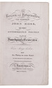
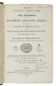
The new sailing directory for the Ethiopic or Southern Atlantic Ocean; including the coasts of Brasil, etc., to the Rio de La Plata, the Coast Thence to Cape Horn, and the African Coast to the Cape of Good Hope, etc.; including the islands between the two coasts.
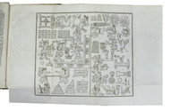
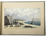
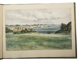
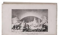
London, printed for R.H. Laurie by J. Rider, 1844. 8vo. With Lauries RHL device on the title-page, and 32 small images in the text, mostly coastal profiles. The title-page includes some lines in sans-serif capitals. Half cloth. XLIV, 472 pp. Full description
€ 1,950
Order Inquire Terms of sale

The 1777 standard history of the discovery of the New World in the 1778 Dutch translation

ROBERTSON, William; [Petrus LOOSJES, transl.]. Geschiedenis van America. Uit het Engelsch vertaald [by P. Loosjes].
Amsterdam, Yntema & Tieboell, 1778. 4 volumes. 8vo. With woodcut title-vignettes; 4 folding maps by Thomas Kitchin (1718-1784), representing (1) the Gulf of Mexico with adjacent countries and islands; (2) Mexico or New Spain; (3) South America and (4) Central America and the South Sea; and a folding plate showing part of the 14th-century Mixtec Codex Vindobonensis. Uniform contemporary half calf. XXXII, 378; 307; XIV, 15-439; IV, 7-322, [65] pp. Full description
€ 1,250
Order Inquire Terms of sale

22 excellent watercolour views of rocky sea-coasts in New Caledonia & Peru

ROMIEUX, Osmond. [Watercolour views of sea-coasts in New Caledonia and Peru].
[New Caledonia & Peru], [1855/60?]. Album: full-sheet leaves (oblong 1mo) (39.5 × 52.5); drawings: oblong folio and oblong 4to. An album with 21 watercolour drawings on paper with views of sea coasts from the shore (24 × 31 cm to 29.5 × 46.5 cm), one with a 22nd watercolour drawing on the back with a similar view, and one with about 15 human figure drawings in graphite pencil on the back. All bear the artists stamp on the front (Lugt 3703) and 4 are signed or initialled by the artist. Richly gold- and blind-tooled green goatskin morocco, white watered silk endleaves. 21 album ll. with 1 drawing mounted on each recto. Full description
€ 18,000
Order Inquire Terms of sale

Rare Dutch adaptation of the account of the second voyage of captain John Ross, with 6 plates

ROSS, John. De reizen en lotgevallen van kapitein John Ross, op zijne ontdekkings togten naar de Noordpools gewesten. Voor jonge lieden ... Uit het Hoogduitsch vertaald.
Amsterdam, Ten Brink & De Vries, 1837. 8vo. With the title-page, 6 plates (including frontispiece) and folding map of the Arctic region all lithographed. Slightly later half cloth. VIII, 247, [1 blank], pp. Full description
€ 400
Order Inquire Terms of sale

Navigational guide covering the coast and coastal waters of Brazil, by the French Imprimerie Royale

ROUSSIN, Albin-Reine. Le pilote du Brésil, ou description des côtes de l'Amérique Méridionale comprises entre l'ile Santa-Catharina et celle de Maranaõ, avec les instructions nécessaires pour atterrir et naviguer sur ces côtes; ...
Paris, Imprimerie Royale, 1827. 8vo. Modern half calf, marbled sides. [3], [1 blank], 241, [1 blank] pp. Full description
€ 1,950
Order Inquire Terms of sale

Mexico's industry and commerce, dedication copy by the author

ROUTIER, Gaston. Le Mexique[.] Limites géographiques. Orographie. Hydrographie. L' agriculture, la flore, la faune et les mines. L' industrie et le commerce.
Paris, H. Le Soudier, 1891. 8vo. With a lithographed folding map of Mexico (34.5 x 46 cm). Contemporary half red morocco, gold-tooled spine. XVII, 110 pp. Full description
€ 2,950
Order Inquire Terms of sale

"Of the utmost importance for the study of Brazilian life" (Borba de Moraes)

RUGENDAS, Johann Moritz. Voyage pittoresque dans le Bresil ... Traduit de l'Allemand par Mr. de Golbery.
Paris, Engelmann & Cie., 1835. 4 parts in 1 volume. Imperial folio (54 x 36 cm). With lithographed half-title and title-page showing a wide variety of decorative lettering, 100 full-page lithographed plates by V. Adam, Villeneuve, Bonnington, A. Joly and others after Rugendas, numbered in 4 parts (30, 20, 30, 20). Contemporary half red sheepskin, gold-tooled spine. [2], 48; 34; 51; 32 pp. Full description
€ 45,000
Order Inquire Terms of sale

Journal of De Ruyter's expedition to West-Africa, the Caribbean and Newfoundland

RUYTER, Michiel de. Journael, gehouden op 's landts-schip de Spiegel ... Onder 't beleydt van den ed. manhaften heer Michiel de Ruyter, als admirael, en de heer Jan Cornelis van Meppelen, als vice-admirael, in den jare 1664 en 1665.
Amsterdam, Jacob Vinckel, 1665. 4to. With an engraved title page by Pieter van de Voorde. Modern half vellum. "82" [=74], [2] pp. Full description
€ 3,750
Order Inquire Terms of sale
158 books found / Show all