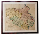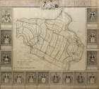

16th-century Dutch map of Persia
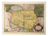
ORTELIUS, Abraham.
Persici sive Sophorum Regni Typus.
Antwerp, Christoph Plantin, 1574. Engraved map (35 x 50 cm), in contemporary hand-colouring and highlighted in gold. Scale 1:9,000,000. Full description
€ 2,500
Antwerp, Christoph Plantin, 1574. Engraved map (35 x 50 cm), in contemporary hand-colouring and highlighted in gold. Scale 1:9,000,000. Full description